Website Manager

American Youth Soccer Organization Providing world class youth soccer programs that enrich children's lives.

Davis AYSO, Region 218

Field Locations and Status

Davis AYSO Primary Field Locations

Field Set Up/Take Down Instructions

To view if Nugget Fields is open or closed please go here. To view if other fields are open or closed go here


Community Park Fields 

203 E 14th St, Davis, CA 95616 
 From the Bay Area: from Highway 80 take Highway 113 North. Take the third exit, Covell Boulevard and turn right (East). After the fourth stoplight (Catalina Drive), just after the bicycle overpass, turn right into the parking lot. Field 6 (select season) and fields 11,12, and 13 (Fall) is adjacent to the parking lot. If you reach F street you have just missed the turn, but turn right onto F so that you can park at the high school parking lot. Proceed south on F street. The first street you reach is 14th. Turn right, then proceed just past the Elementary School, the library, and the Veteran's Memorial Center, then turn right into the High School parking lot. There are many more parking spaces in this HS parking lot than in the parking lot off Covell.
 
From Sacramento: from Highway 80 take the Mace Blvd. exit and turn right onto Mace Blvd. This curves to the west and becomes Covell Blvd. Continue across town until you see a large park on the left (just after you cross the railroad overpass). There is a parking lot the opens onto Covell Blvd, Community Field is immediately adjacent to this. If this lot is full, or if you don't even want to try, then turn left after passing over the railroad overpass onto F street heading south. Then turn right on 14th (the first street you'll come to), the proceed past the elementary school, the library, and the Veteran's Memorial Center, and turn into the High School Parking lot. The soccer fields are to the north, northeast, and and to the east of that parking lot.
 
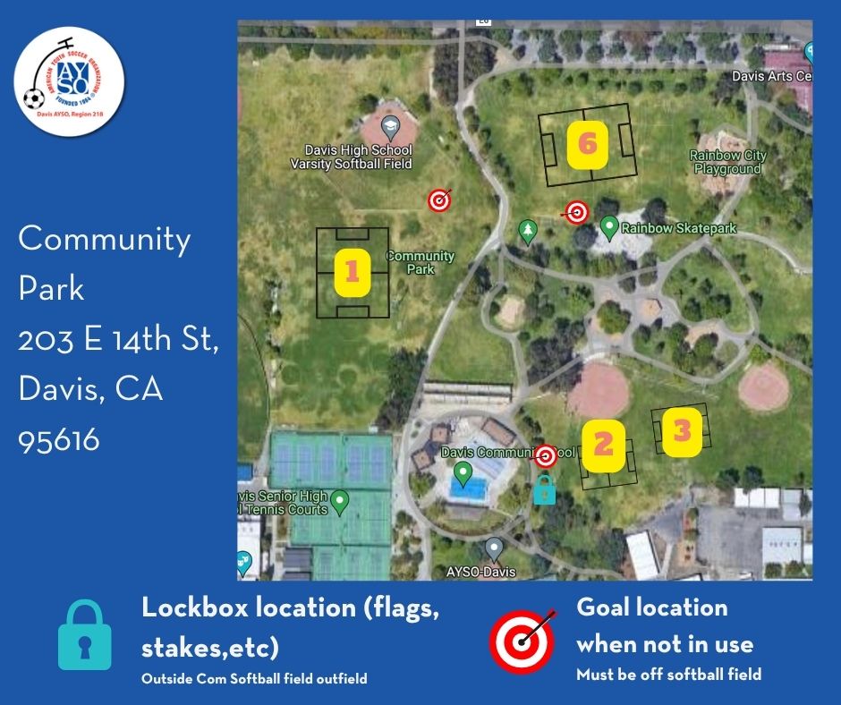
Restrooms are available.

Walnut Park - Montgomery Elementary School


2700 Lillard Dr, Davis, CA 95618

Waln
ut Park and Montgomery Elementary School fields are in South Davis. From Highway 80 take the Richards Blvd exit and go south. Turn right at Lillard Drive(opposite of the shopping center). Montgomery field is adjacent to Montgomery Elementary School, which is at the east end of Walnut Park. Parking is accessible from Lillard Drive. Restrooms are available at the west end of Walnut Park. A map is shown below. Walnut


Northstar Fields & Park 

From the Bay Area: from Interstate 80 take the Highway 113 North exit. Take the third exit, Covell Boulevard and turn right (East). Turn left (North) on "F" Street (the fifth light). After several blocks you will see a wildlife area/ drainage pond on your left. Take the first left after this (Anderson Road). The parking lot for the fields will be on your left.
 
From Sacramento: from Interstate 80 take the Mace Blvd. exit and turn right onto Mace Blvd. This curves to the west and becomes Covell Blvd. Continue across town until you come to F Street, which is a signal just past the railroad overpass. Turn right on F street. After several blocks you will see a wildlife area/ drainage pond on your left. Take the first left after this (Anderson Road). The parking lot for the fields will be on your left.
 
From Woodland: from Highway 113, heading south, exit on Road 29. Go east 1 mile. Just before the railroad tracks turn south on Road 101. Take your first right after about a mile at the flashing yellow light, which is Anderson Road. The most parking spaces and farthest walk is available as a left turn into the park parking. The closest parking and shortest walk is available by continuing on Anderson Road and turning left at the stop sign at Oriole St. Afterturning left, go straight about 50 yards to the small parking lot. This is very close to Northstar West.
 
Restrooms are available on the east end by the parking lot.
 

Nugget Fields - Sandy Motley Park


1801 Moore Blvd Davis, CA 95618

The Nugget Fields are a privately developed set of soccer fields, managed by Davis AYSO. They are immediately adjacent to Sandy Motley Park, a city developed park in the Wildhorse housing development.

From Sacramento: take the Mace Blvd exit and turn right (north). Continue on Mace - it goes around a curve and becomes Covell Boulevard. Continue on Covell until Pole Line Road (there is a shopping center with a Carl's Jr at this corner). Turn right (north) on Pole Line Road. In a few blocks you will see the Nugget fields at your right, turn right on Moore Blvd.

From the Bay Area: from highway 80 take Highway 113 North. The third exit is Covell Boulevard - take that exit and turn right (east) on Covell. Continue on Covell until Pole Line Road (there is a shopping center with a Carl's Jr at this corner). Turn left (north) on Pole Line Road. In a few blocks you will see the Nugget fields at your right, turn right on Moore Blvd.

There are restrooms (portables) by the entrance to the parking lot at Nugget and at the Sandy Motley Park.

Out of Town Field Locations

Capay Valley / Madison / Esparto (Region 1312)

Take Highway 113 north to Road 27.
Take Road 27 West about 10 miles.

Alternatively take Covell Blvd. west to Interstate 505*.
Go North on I-505 about 4 miles.
Go West on Highway 16/Esparto about 4 miles.

Esparto High School: Follow Highway 16 as it turns right into town. After you have turned right the first right is Plainfield Street. The High School is on the northeast corner of Hwy 16 and Plainfield. 
Esparto Middle School: Do NOT turn right on Highway 16 into town - continue straight (west) at this corner about 1/2 mile to Esparto Middle School. 
Esparto Elementary School: Follow Highway 16 as it turns right into town. After you have turned right the first left is Plainfield Street. Turn left on Plainfield and go west to Esparto Elementary School.
ALTERNATELY, take Covell Blvd west from Davis until you reach I-505. Go North on I-505 and exit at Highway 16. Go west on Hwy 16 until you reach Esparto.
Portapotty located on Elementary side, next to crossover bridge.
 
*(Take Highway 113 north to Road 27. Take Road 27 West about 10 miles to Interstate 505. (Alternatively, take Covell Blvd. west to Interstate 505.) Go North on I-505 about 4 miles (from Road 27). Go West on Highway 16/Esparto about 4 miles.)
 
Note: please give your DCA feedback if these instructions are not accurate enough for future teams to follow.
 

Rio Linda (Region 884)

Take Highway 80 towards Reno. Turn North on Interstate 5. From I-5 take Highway 99 North. The first intersection on Hwy 99 is Elkhorn Blvd. Take that exit and head east (right) on Elkhorn. The fields are at Rio Linda High School, on the corner of Elkhorn and Dry Creek Road. The fields are on the west side of the campus off of 10th street. If you use an online mapping service, type in Dry Creek Rd At Elkhorn Blvd Rio Linda, CA 95673.
 

Antelope (Region 884)

Maps for Antelope fields can be found on their web page at http://antelopeayso.org/fields.
To get to the Antelope fields, take Highway 80 towards Reno. Exit at Watt Avenue and go north on Watt.
Lone Oak Park & Center Jr. High: from Watt turn Right on Elverta Road. Turn Left at the second stop light, Black Eagle Dr. Turn Left on Esterbrook. The park is on your left. If you use a mapping service, the intersection of this field is Esterbrook Way At Silver Run Way, Antelope, CA 95843. 
Antelope Crossing/Tetotem Park: FROM DAVIS OR COMING IN HWY 80: From Hwy 80: Take 80 eastbound to the Antelope Exit Turn left and go across the freeway. Stay on Antelope Road as it goes back Northwesterly (will go past Home Depot and across a bridge. At 2nd light past the bridge is Don Julio, turn right. Go until traffic light and turn right onto Heartland Drive. Fields are at northeast corner of Don Julio and Heartland (North loop). Do NOT park where signs say no parking on street or you will be ticketed.
 
Winters (Region 436)
 
Rominger (Shirley Rominger School)Take Covell Blvd and head west to Winters.
(Alternatively take I-80 to I-505, north, then take the Winters exit and go west on Hwy 128.)
Turn right (north) at the red light, Railroad Avenue. Go 0.4 miles and take a left on Niemann. Proceed to about the end of Niemann and the school is on the left. The address for use in online mapping services is 502 Niemann, Winters CA 95694. Coming into Winters after crossing the I-505 freeway you will be on Grant Avenue, also listed as State Highway 128.

Winters Middle School: turn right on Railroad Avenue (the first stop sign in town), then turn left on Anderson Road. The school is near the end of the road at 425 Anderson.

Waggoner School: turn left on Railroad Avenue (the first stop sign in town), then turn right on Edwards. The school is near the end of Edwards. 

National Partners

Our Partners

Contact Us

Davis AYSO, Region 218

P.O. Box 1602 
Davis, California 95617

Email Us: [email protected]
Copyright © 2023 Region 218  |  Privacy Statement |  Terms Of Use |  License Agreement |  Children's Privacy Policy  Login